|
|
 |
Reply
| |
Well, apparently here we are again! The Hurricane Season "typically runs from June 1 to November 30...but then again you never know when a storm may pop up! Just a forum for us that 'could' be affected this year *knocks on wood*. This will provide information on how the plywood states are doing and if we will be seeking refuge to the Marklar locations NOT in the plywood state region. HOPEFULLY, the season will be similar to that of last year (2006) and not 2005! Here are the names of storms for the 2007 season: | Andrea | Barry | Chantal | Dean | Erin | Felix | Gabrielle | | Humberto | Ingrid | Jerry | Karen | Lorenzo | Melissa | Noel | | Olga | Pablo | Rebekah | Sebastien | Tanya | Van | Wendy | |
|
Reply
| |
Currently, 60 MPH and still Tropical Storm Fay...it is a storm that just won't go away! It did make a 3rd landfall over the State of Florida earlier today and is going nowhere phuckin fast....Today was the worst day since this whole phuckin storm started! Here is the latest information: They provide paths as predicted by different meteorological organizations. (3-day is in the solid white and 5-day is the dash portion) This link also includes the latest numbers and location. This link allows you to see how far the categories spread out from center. Following are some storm stats... |
|
Reply
| |
All Central Florida Schools are once again closed tomorrow (I think its because they phucked up today)! The bitch I call Fay has STALLED AGAIN over the State of Floriduh! Power Outages: Orange County 14,767 (where I live) Seminole County 17,996 (where I work) Central Florida 70,000+ Rain Totals 25.00"+ Melbourne Beach 22.00"+ Cocoa Beach 20.25"+ Deltona 16.25"+ Orange City 12.25"+ Sanford 11.50"+ Oviedo 09.50"+ Lake Mary ??.??"+ Orlando (I don't have an exact total by out back is HIGH!) At work, at about 330pm we had winds of 60MPH with gusts up 70MPH! Current winds here 24MPH with gusts up to 44MPH... ...thats it for now will update later...getting tired of these damn updates! |
|
Reply
| |
Louisiana declares emergency as Gustav nears Residents prepare for the worst on cusp of Katrina's third anniversary | 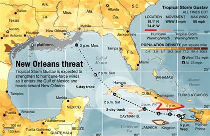
NEW ORLEANS - Louisiana Gov. Bobby Jindal declared a state of emergency Wednesday and activated the National Guard as Tropical Storm Gustav approached the Gulf of Mexico. The storm could crash ashore on the Gulf Coast sometime over the Labor Day weekend as a perilous Category 3 hurricane, though forecasters caution it's difficult to predict the storm's path this early. Jindal said 3,000 National Guard troops will be activated and deployed a day in advance of the storm's expected landfall. An additional 2,000 troops could be called up to duty. About 300 guard troops are already in New Orleans, working with New Orleans police to patrol neighborhoods still devastated from Hurricane Katrina in 2005. "We know it's going to head into the Gulf. After that, we're not sure where it's heading," said Rebecca Waddington, a meteorologist at the National Hurricane Center. "For that reason, everyone in the Gulf needs to be monitoring the storm." City officials were taking no chances, and drawing plans of how to evacuate the city if necessary. New Orleans plans to institute a mandatory evacuation order should a Category 3 or stronger hurricane be within 60 hours of the city. Mayor Ray Nagin left the Democratic National Convention in Denver to help the city prepare. Unlike Katrina, there will be no massive shelter at the Superdome, a plan designed to encourage residents to leave. Instead, the state has arranged for buses and trains to take people to safety. It was unclear what would happen to stragglers. Jerry Sneed, the city's emergency preparedness director, said officials are ready to move about 30,000 people. Nearly 8,000 people had signed up for transportation help by late Wednesday. Coastal residents prepare
At a suburban Lowe's store, employees said portable generators, gasoline cans, bottled water and batteries were selling briskly. Hotels across south Louisiana reported busy booking business as coastal residents considered their inland refuge options. Steve Weaver, 82, and his wife Helen stayed for Katrina �?and wound up being plucked off the roof of their house and by a Coast Guard helicopter. This time, Weaver said he has no inclination to stay. "Everybody learned a lesson about staying, so the highways will be twice as packed this time," Weaver said. Katrina struck New Orleans on Aug. 29, 2005, and its storm surge blasted through the levees that protect the city. Eighty percent of the city was flooded, which set into motion a multibillion-dollar rebuilding program. Since then, the Army Corps of Engineers has spent billions of dollars to improve the levee system. Though experts say the city and surrounding region are safer from hurricanes, the improved levee protection is incomplete and holes remain. Floodgates have been installed on drainage canals in New Orleans to cut off storm surge from entering the city, and levees have been raised and in many places strengthened with concrete. Robert Turner Jr., the regional levee director, said the levee system can handle a storm with the likelihood of occurring every 30 years, what the corps calls a 30-year storm. By comparison, Katrina was a 396-year storm. "There's always the possibility if it comes from the right direction, and if it is large enough to create storm surge in the realm of Katrina, that there could be overtopping" of levees, Turner said. Gustav formed Monday and roared ashore Tuesday as a Category 1 hurricane near the southern Haitian city of Jacmel with top winds near 90 mph, toppling palm trees and flooding the city's Victorian wooden buildings. It triggered flooding and landslides that killed at least 11 people in the Caribbean. It weakened into a tropical storm and appeared headed for Cuba, though is likely to grow stronger in the coming days by feeding on warm open water. Path remains uncertain
David Nolan, an associate professor at University of Miami's Rosenstiel School of Marine and Atmospheric Science, says the uncertainty surrounding the track and strength of Gustav is "very large." Forecasts show the storm hitting anywhere from the Florida Panhandle to Texas. | |
|
Reply
| |
who the hell names these things???? amd the Gov may be over reacting on this one. but then, get that federal aid again.. sheesh |
|
Reply
| |
Gustav likely to push up Labor Day gas prices Drivers might want to top off their tanks early before hitting the road for Labor Day weekend.
Consumers will likely face higher prices at the pump during the busy holiday period as Tropical Storm Gustav swirls toward the Gulf of Mexico on a path that could disrupt energy production. Any damage to oil and gas facilities -- especially along the vulnerable Gulf Coast -- could send retail gas prices spiking back above $4 a gallon, analysts say.
Fears about the storm pushed crude oil above $120 a barrel Thursday, but prices later fell into negative territory as traders bet the government will tap the Strategic Petroleum Reserve if supplies are threatened.
Regardless of where the storm hits though, gas prices look to be headed higher.
"Prices are going to go up pretty soon. You're going to see increases by 5, 10, 15 cents a gallon," said Tom Kloza, publisher and chief analyst at the Oil Price Information Service in Wall, N.J.
That's because supply worries over Gustav have pushed wholesale gas prices up nearly 40 percent along the Gulf in the past few days, meaning struggling filling stations -- even those far away from states like Louisiana and Texas -- will have little choice but to pass on the costs by ratcheting up prices at least some.
Gas prices have dropped steadily over the past month as crude has eased from record levels. A gallon of regular gas shed about half a penny overnight to a new national average of $3.66 -- 11 percent off the all-time high of $4.114 a gallon reached last month.
But if Gustav does major damage to supplies, consumers could see that record shattered.
"If we have a Katrina-type event, you're talking about gas prices going up another 30 percent," said Kloza, whose firm tracks U.S. gas prices by surveying thousands retail outlets around the nation.
Gustav, approaching Jamaica with winds near 70 mph, could regain hurricane strength later Thursday and possibly enter the Gulf of Mexico -- home of a quarter of U.S. crude production -- as a dangerous Category 3 storm early next week.
Oil companies raced to remove workers from oil and gas platforms and braced structures for withering rain and wind.
The concerns pushed light, sweet crude for October delivery as high as $120.50 a barrel on the New York Mercantile Exchange, but prices later settled $2.56 lower at $115.59.
The whipsaw session was exacerbated by low-volume trading heading into the holiday weekend.
Still, oil's retreat in the face of a possibly dangerous storm surprised some oil market watchers, who attributed the move to speculation that the government could release supplies from the Strategic Petroleum Reserve to counter any drop in production from Gustav. The International Energy Agency said the 27-member body was prepared to tap its emergency stocks if needed.
"I think that's taking some of the steam out of this rally," said Jim Ritterbusch, president of energy consultancy Ritterbusch and Associates in Galena, Ill.
Oil was also being pressured by a government report showing that U.S. natural gas supplies jumped much more than expected last week because of weak demand, sending prices for the fuel plummeting.
Natural gas for October delivery fell 56.8 cents, or 6.55 percent, to $8.04 per 1,000 cubic feet.
Further weighing on oil prices was speculation that demand for energy could fall further if Gustav makes landfall.
"If people start canceling their vacations to the Gulf because of the storm, we're probably going to have less demand for fuel than anticipated," said Phil Flynn, analyst at Alaron Trading Corp. in Chicago; Atmospheric models showed Gustav heading toward Louisiana and areas devastated by Hurricanes Katrina three years ago Friday, though it was too early to pinpoint where it would strike.
The storm not only threatens the more than 4,000 oil and gas rigs scattered throughout the Gulf, but also the dozens of oil refineries dotting the vulnerable coastline from Texas to Louisiana.
Royal Dutch Shell Plc has evacuated nearly 400 people and said it will bring in another 270 Thursday.
The company said production will be impacted. BP Plc was also removing personnel from the region that's home to about a quarter of U.S. crude production and much of its natural gas, while ExxonMobil said it was bracing its structures for heavy wind and rain.
Transocean, the world's biggest offshore drilling contractor, is suspending operations at all of its rigs and pulling nearly 1,600 people out of the Gulf.
Weather research firm Planalytics predicted as much as 80 percent of the Gulf's oil and gas production could be shut down as a precaution if Gustav enters the region as a major storm.
Gustav formed Monday and roared ashore Haiti Tuesday as a Category 1 hurricane. The storm triggered flooding and landslides that killed 23 people in the Caribbean. It weakened into a tropical storm, though it is likely to grow stronger in the coming days by drawing energy from warm open water.
Gustav is the first storm of the 2008 Atlantic hurricane season to pose a serious threat to offshore oil and gas installations in the Gulf. In 2005, Katrina and Rita destroyed 109 oil platforms and five drilling rigs. |
|
Reply
| |
Gustav Passes Over Jamaica Bound for Cuba, Gulf Aug. 29 (Bloomberg) -- Gustav returned to hurricane strength after it moved west of Jamaica with torrential rain today, picking up speed as it headed toward Cuba and the U.S. Gulf Coast cities that were ravaged by hurricanes Katrina and Rita in 2005. Cuba issued a hurricane warning for its western areas, which the U.S. National Hurricane Center forecasts Gustav will hit tomorrow. The storm may then reach central Louisiana as a hurricane on Sept. 2 before moving northwest into areas of Louisiana and Texas, the center forecast. President George W. Bush declared a state of emergency for Louisiana, three years to the day after Katrina left more than 80 percent of New Orleans under water and caused more than $81 billion in damage. That hurricane was followed three weeks later by Rita, which ravaged central Louisiana and far eastern Texas, the same areas now threatened by Gustav. ``A land strike to the west of New Orleans will place this great city within the most dangerous part of the storm,'' said Jim Rouiller, a senior energy meteorologist with Planalytics Inc., a forecaster based in Wayne, Pennsylvania. ``Gustav has the potential to generate much more damage than Katrina did.'' Gustav will ``likely explode into a major hurricane over the next two days as it tracks on a west to northwesterly course across the northwestern Caribbean toward western Cuba and the Cayman Islands,'' said Rouiller. Parts of the Florida Keys were put under a storm watch late today. Hurricane warnings were posted for the Cayman Islands and western Cuba including the city of Havana. Bush ordered federal aid to supplement state and local efforts, the White House said by e-mail. Texas, Mississippi and Louisiana issued their own state emergency and disaster declarations and alerted National Guard units. Ready for Travel New Orleans Mayor C. Ray Nagin urged an estimated 30,000 residents needing assistance to register with a program to help them get out of the city if Gustav strikes. Louisiana has about 800 buses mustered for a possible evacuation; Amtrak trains are also available if needed. ``We have to take these storms seriously,'' Governor Bobby Jindal said at a press conference yesterday. ``We as Louisianans have to be better prepared.'' Gustav will be the first test for federal officials of new procedures since Hurricane Katrina, Homeland Security Secretary Michael Chertoff said in Washington yesterday before flying to Louisiana. The Bush administration was widely criticized for a slow response after the 2005 storm. The U.S. Federal Emergency Management Agency said it had food, water and supplies ready to move into the area. ``The upper Texas coastline to Louisiana will remain most at risk to receive the brunt,'' Rouiller said today. ``Landfall projections into this high-risk target zone are expected to occur very late Monday night and Tuesday.'' Heading for Caymans Gustav regained hurricane strength with sustained winds of 75 miles (120 kilometers) per hour as of 5 p.m. Miami time today and was centered 100 miles east of Grand Cayman, the U.S. National Hurricane Center said on its Web site. It is heading west-northwest at 12 mph, about twice yesterday's speed. Gustav is predicted to bring as much as 25 inches (64 centimeters) of rain to Jamaica and the Cayman Islands on a track toward the western tip of Cuba, reaching the Gulf of Mexico by Aug. 31, the center said. Jamaica's Office of Disaster Preparedness and Emergency Management warned of ``extensive flash flooding'' as heavy rainfall continues into the night, it said in a bulletin. There were no confirmed casualties caused by Gustav in Jamaica, although 60 people were reported killed when the storm hit Haiti and the Dominican Republic earlier in the week. The storm lead to the deaths of 51 people in Haiti, Agence France-Presse reported. In the neighboring Dominican Republic, eight people died and two were hurt in a landslide, the country's Center of Emergency Operations said on its Web site. Preparing to Move Some southern Louisiana parishes, where several oil refineries are located, plan to evacuate civilians today or tomorrow, the local governments said on their Web sites. St. Charles Parish, west of New Orleans, accelerated its emergency plan to begin assisted evacuations today and mandatory evacuations will likely take place at noon local time tomorrow. St. Bernard Parish officials anticipate mandatory evacuations tomorrow. U.S. oil and gas platforms and pipelines are most concentrated in the waters south of Louisiana and east of Texas. Offshore fields in the Gulf accounted for 26 percent of total U.S. crude production and 12 percent of natural gas output in April, according to the U.S. Energy Department. Producers including Royal Dutch Shell Plc and BP Plc evacuated workers from platforms in the Gulf region. Oil Prices Crude oil for October delivery rose 42 cents to $116.06 a barrel as of 1:47 p.m. on the New York Mercantile Exchange. Futures are up 2.5 percent this week, the biggest gain since the week ended July 4. Oil is up 60 percent from a year ago. The hurricane center also is monitoring Tropical Storm Hanna, which was about 215 miles north-northeast of the Caribbean's northern Leeward Islands and heading northwest at 12 mph as of 11 a.m. Miami time. The system had maximum sustained winds of 50 mph, and may become a hurricane over the weekend, the center said. Hanna is predicted to turn west and then southwest toward the central Bahamas next week. Landfall isn't forecast over the next five days, according to the center's Web site |
|
Reply
| |
New York search and rescue team heads to Gulf Coast Three years ago, FDNY Battalion Chief Joseph Downey was part of a search and rescue unit that worked in Biloxi, Miss., after Hurricane Katrina barreled into the Gulf Coast.
"Entire towns were wiped out," Downey recalled yesterday, as he and more than 30 New York City firefighters and police officers headed south again, this time in anticipation of Hurricane Gustav. Forecasters predicted Gustav would hit the Gulf Coast region tomorrow.
With news that Gustav was expected to swell into a Category 5 hurricane, Downey, 46, of West Islip, said members of his team, named Task Force 1, were preparing for the worst.
"If it hits as a Category 5, we're expecting a tremendous amount of damage," Downey said during a telephone interview as the team traveled near Roanoke, Va.
The Federal Emergency Management Agency activated the first responders on Friday, said Chris Gilbride, a spokesman for New York City's Office of Emergency Management.
"They're experts in search and rescue in confined spaces," Gilbride said.
When the team left yesterday, Gustav was intensifying toward a Category 5 hurricane - the highest - with maximum sustained winds above 155 mph and storm surges 18 feet above normal.
Downey said his team was "excited to go down and help" but also had to be patient. FEMA planned for Task Force 1 to be in Atlanta today and wait for further orders from there.
All the driving yesterday came after hours of work on Friday loading equipment, Downey said.
The storm could land anywhere from Mississippi to Texas.
New York's Task Force 1 is one of 28 search and rescue teams around the nation that can be activated by FEMA in an emergency. New York's team has two tractor-trailers filled with equipment and supplies to sustain the team for 72 hours, Gilbride said.
The team consists of 35 people and 10 vehicles, including the tractor-trailers.
FEMA established an Urban Search and Rescue System in 1989. New York's Task Force 1 became a member of FEMA's system in 1992. The unit is made up of New York City first responders prepared to deploy within six hours of notification. |
|
Reply
| |
Gustav hits towns outside New Orleans hardest Levee breach feared in southernmost parish as storm moves toward Texas NEW ORLEANS - New Orleans' levees were holding their own Monday, but other communities across southern Louisiana saw Hurricane Gustav slam into their backyards �?tossing trees onto homes and pushing floodwalls to their limits. The nearly 2 million people who left coastal Louisiana on a mandatory evacuation order watched TV coverage from shelters and hotel rooms hundreds of miles away. While New Orleans wasn't submerged, there were scores of homes that suffered damage. More than 1 million customers were without power. One community in southeast Louisiana feared its levee wouldn't hold. As many as 300 homes in Plaquemines Parish were threatened, and the parish president called a television station to issue an urgent plea to any residents who were left to flee to the Mississippi River, where officials would evacuate them. It's overtopping. There's a possibility it's going to be compromised," said Phil Truxillo, an emergency official in Plaquemines, the state's southernmost parish located at the mouth of the Mississippi River. In Terrebonne Parish, in the southeast part of the state, several homes had torn roofs, but winds were still too fierce for officials to fan out and assess how bad the damage was. Keith Cologne of Chauvin, a town in Terrebonne, looked dejected after talking by telephone to a friend who didn't evacuate. "They said it's bad, real bad. There are roofs lying all over. It's all gone," said Cologne, staying at a hotel in Orange Beach, Ala. The storm was expected to move into Texas overnight and drop as much as 20 inches of rain there by Thursday. Seven U.S. deaths were tied to Gustav: four evacuees were killed in Georgia when their car struck a tree; two people were crushed by a tree in Baton Rouge; and a woman leaving New Orleans died in a car accident. While Louisiana residents dealt with Gustav, communities from Miami to the Outer Banks of North Carolina were surprised Monday by the news that Tropical Storm Hanna had become a hurricane and could make landfall somewhere along that stretch of coast in a few days. And a new tropical storm, Ike, formed east of Hanna in the Atlantic on Monday. Forecasters said it could become a hurricane in a few days and was moving to the west-northwest but that it was too early to project landfall anywhere. Optimism in the Big Easy
In New Orleans, city pumps at levees �?still only partially rebuilt after Hurricane Katrina �?were able to keep up with the surge, an Army Corps of Engineers official said Monday. Maj. Gen. Don Riley, deputy commander of the engineers, told a briefing by the Federal Emergency Management Agency that the levees in the greatest danger were in the southern part of Lafourche Parish southwest of New Orleans and closer to where Gustav came ashore. "The only ones that we think are in the greatest danger are in south Lafourche Parish," he said. He said that although waves washing over the tops of the levees in New Orleans and high water pressing the walls raised the potential for problems, officials were "confident in the resilience" of the levees rebuilt after Katrina. "There's no question they have a safer system now than they did during Katrina," one official said of the levee system. Up to 50,000 National Guard troops have been authorized by Secretary of Defense Robert Gates to help in the aftermath of the hurricane, Maj. Bill Etter of the National Guard said. "We've seen a very well-prepared nation for Hurricane Gustav," a FEMA official said. In the Upper Ninth Ward, about half the streets closest to the Industrial Canal were flooded with ankle- to knee-deep water as the road dipped and rose. Floodwater overtopped the canal but did not breach it. Landfall near Cocodrie
The National Hurricane Center in Miami said Gustav made landfall Monday near Cocodrie, a low-lying community in Louisiana’s Cajun country about 72 miles southwest of New Orleans. By 3 p.m. ET, Gustav's winds had dropped to 90 mph, reducing it from a Category 2 to a Category 1 hurricane. The extent of the damage in Cajun country was not immediately clear. State officials said they had still not reached anyone at Port Fourchon, a vital hub for the energy industry where huge amounts of oil and gas are piped inland to refineries. The eye of Gustav passed about 20 miles from the port and there were fears the damage there could be extensive. Forecasters once feared a storm that would arrive as a devastating Category 4 with much more powerful winds. While New Orleans avoided a direct hit, the storm could be devastating where it did strike. For most of the past half century, the bayou communities that thrived in the Barataria basin have watched their land literally disappear. A combination of factors �?oil drilling, hurricanes, river levees, damming of rivers �?have destroyed marshes and swamps that once flourished in this river delta. Entire towns in the basin of the Mississippi delta have disappeared because of land loss. The rates of loss are among the highest in the world; erosion has left it with virtually no natural buffer. |
|
Reply
| |
Hanna eyes Bahamas after battering Haiti Emergency declared in Fla. as experts warn storm could hit New York SAINT-MARC, Haiti - Far-reaching Tropical Storm Hanna drenched flood-plagued Haiti on Wednesday, adding to the miseries of a country that has lost 110 lives to mudslides and flooding since mid-August. Meanwhile, Tropical Storm Ike was cruising westward across the Atlantic and had strengthened to hurricane status as it moved toward the Bahamas. Hanna had been drifting south and east before it swung toward the north-northwest on Wednesday. It was expected to sweep across the Bahamas and then start climbing along the U.S. coastline by the weekend, according to the U.S. National Hurricane Center in Miami. Experts said there is a 20 percent chance Hanna could bring tropical storm force winds to New York City. Haitian authorities on Wednesday reported five more deaths caused by Hanna, raising the toll to 26. A day after sending Haitian families scrambling onto rooftops to avoid flooding, Tropical Storm Hanna was meandering off the country's northern coast Wednesday, dumping heavy rain on much of Hispaniola. But Hanna was expected to begin moving over the Bahamas later in the day. A day earlier, Hanna added to the misery in Haiti, a country still recovering from drenchings by Hurricane Gustav and Tropical Storm Fay in the past two weeks. In all, floods and mudslides from the three storms have killed more than 100 people as Haiti's deforested hills melted away in torrential rains. ‘They are screaming for help�?/STRONG>
Families screamed for help from rooftops Tuesday in a flooded city as U.N. peacekeepers and rescue convoys tried in vain to reach them. By Tuesday night, Hanna claimed 21 lives in Haiti, including 12 dead in the state containing the cutoff city of Gonaives, said Marie Alta Jean-Baptiste of the country's civil protection office in Port-au-Prince, the capital. Iris Norsil, 20, managed to flee Gonaives on Haiti's western shore and told The Associated Press people there were isolated by muddy floodwaters as evening fell, seeking refuge on rooftops as wind gusts drove horizontal sheets of rain. "They are screaming for help," Norsil said as a U.N. aid convoy tried unsuccessfully to drive into Gonaives, now surrounded by a virtual lake of floodwaters. A team of AP journalists accompanied the convoy. Another convoy carrying Prime Minister Michele Pierre-Louis had to abandon efforts at getting into Gonaives when one of the cars was nearly swept away, said Julian Frantz, a Haitian police officer who was providing security for the group. Rising waters
Floodwaters rose rapidly outside Gonaives, where Norsil and scores of other residents who abandoned the low-lying city shivered violently in soaked clothing, nervously eyeing the rushing, debris-clogged waters. "The situation is as bad as it can be," said Vadre Louis, a U.N. official in Gonaives. "The wind is ripping up trees. Houses are flooded with water. Cars can't drive on the street. You can't rescue anyone, wherever they may be." Those who could move clutched mattresses, chairs and other belongings as they slogged through waist-high floodwaters. Emergency in Florida
At 5 a.m. EDT Wednesday, Hanna's maximum sustained winds were near 60 mph, but the U.S. National Hurricane Center in Miami said it could regain hurricane strength and turn toward the east coast of Florida, Georgia or South Carolina in the next few days. In Florida, Gov. Charlie Crist issued a state of emergency in preparation for Hanna's possible landfall there. Crist said Florida should be ready for flash floods and winds up to 111 mph. The storm was drifting toward the north near 2 mph with forecasters expecting Hanna to move across the southeastern Bahamas later in the day. In Puerto Rico, flooding was blamed for the drowning death of a Colombian university student in a raging river. The man's Brazilian friend was missing despite a desperate search in the water. Swirling slowly through the southern Bahamas on Tuesday, Hanna lingered over the island of Great Inagua for hours, toppling power lines but otherwise doing little damage. There were reports of heavy winds stripping shingles from roofs and knocking down trees, but no injuries, said Chrystal Glinton, a spokeswoman for the Bahamas' National Emergency Management Agency. "Everyone is alive and well," Glinton said. "The damages have been minimal." The same could not be said for Haiti, a country particularly vulnerable to devastating floods because of its steep terrain and hills that have been deforested for agriculture and by peasants who burn trees for charcoal. In the fertile Artibonite Valley, rice fields were flooded and farm animals huddled on small plots of dry land. In the village of L'Ester, Wilson Elie, a local official, said rain had overwhelmed his community and he pleaded for government help. The people cannot live in water," Elie said. Tropical storm winds extended out 230 miles from Hanna's center. Ike closes in
Meanwhile, Tropical Storm Ike was cruising westward across the Atlantic has strengthened to hurricane status and projected to near the Bahamas by Sunday. Just behind Ike was Tropical Storm Josephine, which gained a little strength with top winds near 60 mph. Forecasters expected Josephine to get stronger over the day. And in the Pacific, Tropical Storm Karina formed south of Mexico's Baja California Peninsula, on a path leading out to sea. It weakened to a tropical depression Tuesday night and was expected to further weaken over the next few days. |
|
Reply
| | | From: LadySue | Sent: 9/3/2008 11:04 PM |
OMG! How horrible! I know how much tornados and floods can do, but a hurricane is like a combo storm!  |
|
Reply
| |
Southeast U.S. braces for Hanna, then Ike
Storm leaves 61 dead in Haiti; U.S. coast prepares for high winds, rain WILMINGTON, N.C. - Some Southeastern states declared emergencies and officials urged residents to head inland Thursday as Tropical Storm Hanna headed toward the U.S. Atlantic coast, where it could bring high winds and rain from South Carolina all the way to Maine.
Meanwhile, disaster planners cast a wary eye to a suddenly ferocious-looking Hurricane Ike strengthening in the Atlantic. And with power outages and other problems from Hurricane Gustav still lingering in Louisiana, Arkansas and Mississippi, the Federal Emergency Management Agency and other relief groups could soon find themselves juggling fallout from three storms. Rain and wind from Hanna could start as early as Friday night in the South, where some residents shuttered houses and stocked up on food and sandbags, coastal parks closed and schools canceled events and changed sports schedules.
Officials did not order people from their homes in advance of the storm, which was expected to make landfall early Saturday. Path of destruction
Hanna left a deadly trail of destruction in Haiti before picking up a little speed as it headed from the Bahamas toward the southeastern U.S. By Thursday afternoon, Hanna was about 670 miles south-southeast of Wilmington. The storm was blamed for at least 61 deaths in Haiti, mostly from flooding, the Caribbean country's Civil Protection Department said. Department spokesman Abel Nazaire said 21 of the deaths were in Gonaives, Haiti's fourth largest city, which has been almost entirely cut off by floodwaters Bahamas National Security Minister Tommy Turnquest canceled all leave for the Bahamas Royal Defence Force to keep soldiers on standby for disaster response. In the U.S., the governors of Virginia and North Carolina declared states of emergency, freeing up state resources for storm response. South Carolina opened several emergency shelters and restricted port hours and Gov. Mark Sanford urged people to leave flood-prone areas and mobile homes in two northern counties by Friday afternoon. In North Carolina, some schools prepared to open shelters and officials planned to close ports Friday.
Still, some coastal residents scoffed at what appeared to be a storm that could hit as a low-level hurricane.
Instead, they turned to the next worry brewing in the Atlantic: Ike, which strengthened quickly from a tropical storm to a Category 4 hurricane Wednesday. Forecasters said it was too early to say if and where Ike might threaten land.
"Ike is a very scary storm," said Mike Hughes, spokesman for a North Carolina power company that closely tracks hurricanes as they head through the Atlantic.
Strain on resources
The line of storms comes on the heels of Gustav, whose aftermath had Louisiana residents living in shelters and without power. Aid agencies now face the task of trying to assist everyone potentially at risk from all the storms.
In 2004, the then-head of FEMA, David Paulison, said three major hurricanes in just over a month had strained �?but did not ultimately hobble �?the agency's resources and staffing.
On Thursday, FEMA officials said they prepared in advance for this season, sending teams to Louisiana while others planned for Hanna.
The American Red Cross was moving supplies, equipment and people into areas Hanna might affect, said spokesman Pat McCrummen. McCrummen said the organization has distributed 3.5 million meals to people affected by Gustav and supplies for the East Coast were in nearby warehouses.
Hanna chugged just east of the Bahamas Thursday with winds near 65 mph, though forecasters said it could return to hurricane strength Friday before reaching the U.S. coast.
A hurricane watch was issued for Edisto Beach, S.C., north to Okracoke Inlet, N.C., while a tropical storm watch was issued from Edisto Beach south to Altamaha Sound, Ga.
Preparing for landfall
South Carolina planned to send 70 state troopers to monitor traffic along evacuation routes. The state National Guard said its troops were not asked to assist and would likely be released from duty. But in Charleston, south of where the storm was expected to hit, officials passed out 10,000 sandbags and urged residents in low-lying areas to head inland. Hundreds of miles north, emergency managers in New England also planned for Hanna, which forecasters said could hit this weekend with heavy rain and strong winds. In Providence, R.I., workers cleared storm drains and stocked up on sandbags and residents were urged to stock up on batteries and first aid supplies.
In Massachusetts, emergency managers also kept a close eye on the storm track.
"If nothing else it's a good dress rehearsal for Ike if Ike were to come," said Peter Judge, a spokesman for the Massachusetts Emergency Management Agency.
In Kure Beach, N.C., a few houses, a trailer and a real estate office were boarded up and the town hall had metal storm shutters.
Jimbo Andrews nursed a Coke at a local watering hole where bartender Kassie Jones made plans for a Friday night hurricane party. Andrews said he keeps hurricane supplies at his house year-round and planned to leave if Ike hit.
As for Hanna? It looked to get him out of some weekend yard work.
"No sense in going to the trouble when you got a storm coming," he said. |
|
Reply
| |
Ike storm surge begins; Houston hunkers down People still in low-lying areas warned they could ‘face certain death�?/H2> GALVESTON, Texas - Hurricane Ike steamed through the Gulf of Mexico on Friday on a track toward the nation’s fourth-largest city, where authorities told residents to brace rather than flee, even as people in low-lying areas closer to the gulf were told to leave or “face certain death.�? Forecasters warned that a potentially deadly 20-foot wall of water could make its way inland, and coastal towns were already seeing a storm surge at midday Friday. In the upscale West End of Galveston, the first floors of houses were underwater, and streets were impassable because of debris scattered by the surge. The Coast Guard began airlifting several dozen residents from their homes at Bolivar Peninsula along the Texas coast Friday after the wind and rain became too much for them. Ike’s 105-mph winds and potential 50-foot waves at first prevented the Coast Guard from attempting a risky helicopter rescue of 22 people aboard a large freighter hauling petroleum coke that broke down about 90 miles southeast of Galveston. By midday, aircraft were dispatched to try to airlift the crew. Ike was expected to arrive around midnight Friday, and forecasters said it could take 12 hours to move out of southeast Texas. But the massive system was already buffeting Texas and Louisiana, causing flooding around Galveston and even along the Louisiana coast, which was still recovering from Hurricane Gustav. The National Weather Service warned that people not heeding evacuation orders in low-lying parts of the coast “may face certain death�?and that many homes on the coast would be destroyed. Waves over Galveston seawall
In Galveston, residents nervously eyed the seashore as white waves as tall as 15 feet bashed over the seawall and crept into clusters of houses perched on stilts. “I’ve never seen it like that before. I’m scared, I’m leaving,�?said Roy Patel, manager of the Economy Motel. He had boarded up his on the sea front and was headed to the mainland by car. It was also enough to scare away Tony Munoz and his wife, Jennifer, who went down to the water to take pictures and then decided that riding out the storm wasn’t a good idea after all. “We started seeing water come up on the streets, then we saw this. We just loaded up everything, got the pets, we’re leaving,�?Tony Munoz said. “I've been through storms before but this is different.�? Galveston, a barrier island and beach town about 50 miles southeast of downtown Houston, was the scene of the nation’s deadliest hurricane, the great storm of 1900, which left at least 6,000 dead. The current storm is so big it could inflict a punishing blow even in those areas that do not get a direct hit. But officials in Houston took a calculated risk and told people to stay put. That order was an attempt to avoid a repeat of the chaos and death that ensued after residents were ordered to evacuate Houston when Hurricane Rita threatened the city in 2005. In that instance, the number of deaths attributed to the evacuation was more than 10 times the toll from the storm. Forecasters warned that because of Ike’s size and the shallow Texas coastal waters, it could produce waves of perhaps 50 feet. It could also dump 10 inches or more It will be, in candor, something that people will be scared of,�?Houston Mayor Bill White warned. “A number of people in this community have not experienced the magnitude of these winds.�? If the storm stays on its projected path, it could head up the Houston ship channel and through Galveston Bay, which Homeland Security Secretary Michael Chertoff called a nightmare scenario. At 2 p.m. ET Friday, Ike was a Category 2 storm with maximum sustained winds near 105 mph. It was centered about 165 miles southeast of Galveston, moving west-northwest near 12 mph. A turn toward the northwest was expected later in the day, with a turn toward the north expected Saturday. Evacuation orders were issued Thursday for coastal parts of the Houston area and Galveston Island. They joined residents of at least nine districts in flood-prone areas of Harris County, in which Houston is located, along with hundreds of thousands of fellow Texans in counties up and down the coastline, who were also warned to leave. Stores across Houston reported that they were running low on batteries, drinking water and other storm supplies, and many grocery stores were closing early Friday afternoon. The oil and gas industry was closely watching the storm because it was headed straight for the nation’s biggest complex of refineries and petrochemical plants. The upper Texas coast accounts for one-fifth of U.S. refining capacity. Forecasters at the private Planalytics weather service saw “major and long-term damage likely at the major refining cities.�? |
|
Reply
| |
Ike’s potential impact The Department of Homeland Security provided this assessment of the potential impact of Hurricane Ike to NBC News on Friday: Storm surge
�?572,000 people within storm surge area
�?6 drinking water plants affected by storm surge
�?34 wastewater treatment facilities affected by storm surge
�?54 police stations, 89 fire stations and 32 ambulance services affected by storm surge
�?10 hospitals with more than 10 beds affected by storm surge
�?47 nursing homes affected by storm surge
�?7 wire centers affected by storm surge
�?140 electric power substations affected by storm surge
�?48 non-nuclear generating units affected by surge
�?10 industrial plants including oil refineries and chemical plants are co-located with 41 generators affected by storm surge Power failures
�?5.2 million customers may lose power in Texas
�?99 drinking water plants in outage area (only 14 plants serve more than 50,000)
�?More than 1,500 wastewater treatment facilities are in outage area
�?799 police stations, 1,973 fire stations and 641 ambulance services within outage area
�?256 hospitals with more than 50 beds within outage area
�?1,263 Nursing Homes within electric power outage area Petroleum, natural gas
�?95 percent of Gulf of Mexico oil and natural gas production suspended
�?1.25 million barrels per day of oil production (6 percent) of U.S. petroleum demand
�?6.9 billion cubic feet per day of natural gas production (11 percent of U.S. daily average natural gas demand |
|
Reply
| |
A great hurricane tracking page for Ike |
|
Reply
| |
thanks for the link, Dark |
|
|
|

 Important Announcement

 First
First
 Return to General